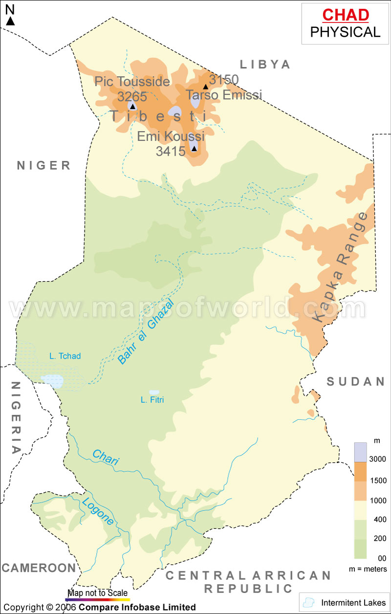
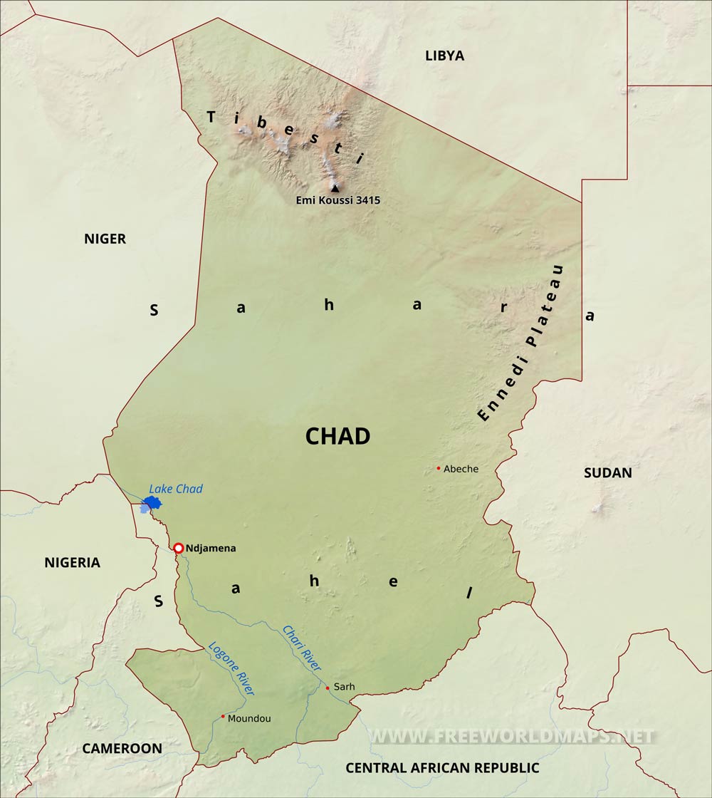
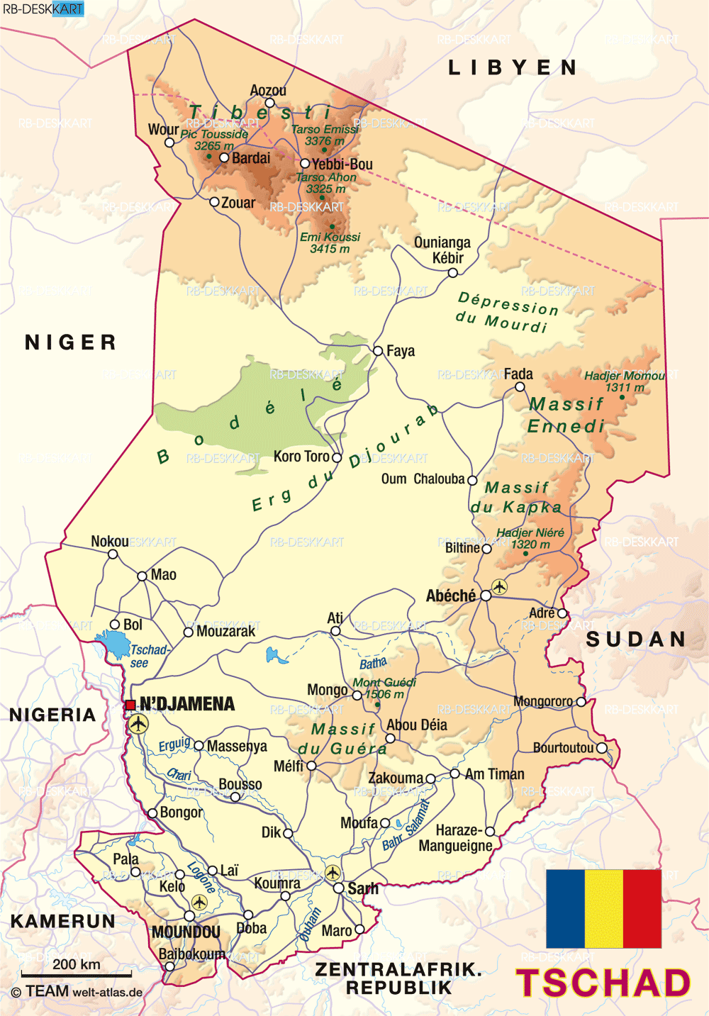
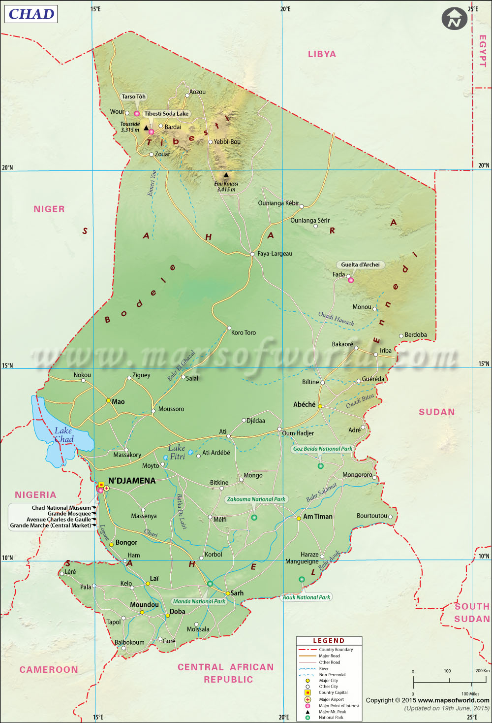
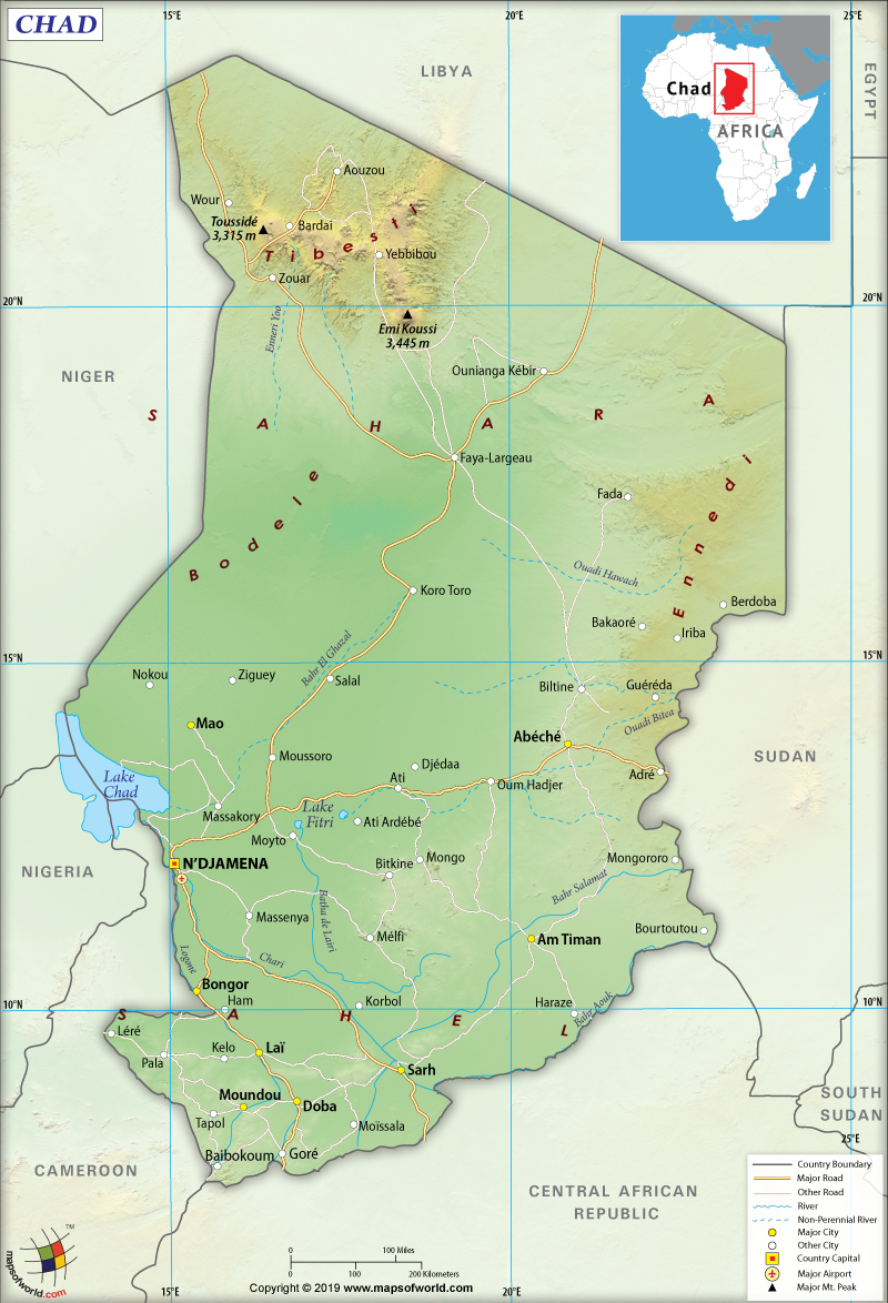
- What are the main physical features shown on a physical map of Chad? The main physical features of Chad include the vast Sahara Desert to the north, the semi-arid Sahel belt in the central region, the Tibesti Mountains in the far north with Emi Koussi, Lake Chad in the west, and the Chari and Logone river systems in the south.
- Where is Lake Chad located and what is its significance on the map? Lake Chad is located in the western part of the country, bordering Niger, Nigeria, and Cameroon. It is a vital freshwater source and a significant ecological feature, though it has dramatically shrunk over recent decades.
- What mountain range dominates northern Chad on a physical map? The Tibesti Mountains, a volcanic range, dominate northern Chad. It features Emi Koussi, the highest peak in Chad and the Sahara, making it a prominent geographical landmark on any physical map.
- How does the Sahara Desert influence Chad's physical geography? The Sahara Desert covers a substantial portion of northern Chad, creating an extremely arid environment with vast sand dunes and rocky plains. This greatly influences Chad's climate, population distribution, and resource availability, notably impacting water access.
- Are there major rivers visible on Chad's physical map? Yes, the Chari and Logone rivers are the two most significant rivers visible on Chad's physical map. They flow through the southern and central parts of the country, converging before emptying into Lake Chad, providing essential water for agriculture and communities.
- What is the Sahel region and where is it on Chad's physical map? The Sahel is a semi-arid transitional belt located across central Chad, situated between the Sahara Desert to the north and the more humid savannas to the south. It is characterized by grasslands and scattered trees and is prone to desertification.
- How does Chad's landlocked status impact its physical features? Chad's landlocked status means it has no direct access to the sea. This significantly affects its climate, relying entirely on internal water sources like Lake Chad and its river systems, and shapes its ecosystems to be adapted to these conditions, as depicted on its physical map.
Explore the fascinating physical map of Chad a central African nation showcasing incredibly diverse landscapes from vast deserts to crucial river systems. Understanding Chad's geography is essential for grasping its ecological challenges and cultural richness. Its landlocked position means internal features like Lake Chad and the Tibesti Mountains profoundly shape its environment. Discover the arid expanse of the Sahara Desert in the north, the semi-arid Sahel belt across its center, and the more fertile savanna regions in the south nourished by the Chari and Logone rivers. This guide offers insights into how these natural elements define Chad providing valuable context for students travelers and geography enthusiasts alike. Navigating Chad's terrain virtually helps appreciate its unique position in Africa. Learn about the dramatic changes impacting Lake Chad and the towering presence of Emi Koussi within the Tibesti range. This information serves as a vital resource for anyone seeking to understand Chad's physical characteristics.
- What are Chad's prominent physical features? - Chad's physical map showcases Lake Chad in the west, the vast Sahara Desert to the north, and the imposing Tibesti Mountains in the far north. The central region features the semi-arid Sahel Belt, transitioning to more fertile plains in the south, crisscrossed by the Chari and Logone rivers. Its landlocked position emphasizes internal water systems.
- How has Lake Chad changed on physical maps? - Lake Chad, a critical freshwater source, has dramatically shrunk over the decades due to climate change and increased irrigation. Physical maps from different eras clearly illustrate this significant reduction, highlighting environmental concerns and its impact on regional ecosystems and communities relying on its waters.
- Which mountain range is key on a physical map of northern Chad? - The Tibesti Mountains are the dominant mountain range in northern Chad, clearly visible on any physical map. This volcanic range includes Emi Koussi, Chad's highest peak. Its rugged terrain and cooler temperatures stand in stark contrast to the surrounding Sahara Desert, forming a distinct geographical region.
- What desert areas appear on Chad's physical map? - The vast Sahara Desert covers a significant portion of northern Chad on its physical map. This arid region features extensive sand dunes, rocky plateaus, and sparse vegetation, defining the nation's northern landscape. It creates extreme environmental conditions influencing population distribution and resource availability within Chad.
- What major rivers flow through Chad as seen on a physical map? - The Chari and Logone rivers are the most significant river systems flowing through Chad, particularly in the southern region. These rivers converge and then flow into Lake Chad, serving as crucial lifelines for agriculture, transportation, and communities. They are prominently featured on physical maps, illustrating the country's hydrology.
- What characterizes the Sahel on Chad's physical map? - The Sahel region, appearing as a semi-arid belt across central Chad on a physical map, is characterized by its transition zone between the Sahara Desert to the north and the more humid savannas to the south. It features grasslands and scattered trees, supporting pastoralism and rain-fed agriculture, but is vulnerable to desertification.
- Why is Chad's landlocked status important for its physical map? - Chad's landlocked status is crucial because it means all its major water bodies, like Lake Chad and the Chari-Logone river system, are entirely internal. This reliance on internal water sources and the absence of direct access to oceans significantly shapes its climate, ecosystems, and economic development, highlighted on its physical map.
Chad's physical map is a canvas of contrasts a testament to Central Africa's diverse geography. From the vast Sahara Desert to the life-giving Chari River system understanding its landforms is key to appreciating this unique nation. Whether you are a student a remote explorer or simply curious about global landscapes this guide will illuminate the major physical features that define Chad.
Frequently Asked Questions
Where can I find the most detailed physical map of Chad online?
The absolute best locations to find detailed physical maps of Chad are on official government mapping sites like the CIA World Factbook, educational resources such as National Geographic, and reputable cartography archives like Perry-Castañeda Library Map Collection. These sources provide high-resolution and accurate data.
How can I use Local Maps to explore Chad's geographical features?
Pull up your preferred mobile Maps app like Google Maps to verify real-time satellite imagery and terrain views of Chad. Use the zoom function to discover details of the Tibesti Mountains or trace the Chari River. The Local MAP features are excellent for virtual exploration.
What are the best times to virtually explore Chad's physical geography?
Virtually exploring Chad's physical geography is best done during your local daytime hours when satellite imagery often appears clearest on digital maps. For academic or detailed study any time is suitable allowing you to focus on specific features like the arid northern regions or the southern river basins without external distraction.
Quick Physical Features Guide
- Lake Chad | West African Sahel border Chad Niger Nigeria Cameroon
- Tibesti Mountains | Northern Chad Sahara Emi Koussi peak
- Sahara Desert | Northern Chad vast arid landscape
- Sahel Belt | Central Chad semi-arid transition zone
- Chari Logone River System | Southern Chad major water source flowing into Lake Chad
Lake Chad shrinkage, Tibesti Mountains, Sahara Desert, Sahel Belt, Chari-Logone River system, landlocked geography, Emi Koussi, Central Africa topography.


Physical Map Of Chad Ezilon Maps All For One Chad Physical Map . Chad Physical Map Order And Download Chad Physical Map Chad Physical Map 324x324 . Chad Satellite Map Australia To Chad Map Chad Language Map Physical . Chad Physical Map Cd Relief 1982 . Physical Map Of Chad Ezilon Maps Chad Map Features Locator



Map Of Chad Africa Cd Map Admin 2016 . Physical Map Of Chad Maps Of Chad Maps Of Africa GIF Map Maps Physical Map Of Chad Small . Chad Physical Map Physical Map Of Chad Chad Physical Map . Map Of Chad Chad Physical Map . Physical Map Of Chad Ezilon Maps Large Detailed Road Map Of Chad


Physical Map Of Chad Chad Political Map . Physical Map Of Chad Map Of Chad . Chad Physical Composition Stock Of Atlas Chad Physical Composition Area Map Azimuthal Equidistant Projection Color Full Rasters Borders 187252001 . Map Of Chad Africa Large Location Map Of Chad In Africa . Physical Map Of Chad Physical Map Chad



Detailed Physical Map Of Chad 67922447 Vector Art At Vecteezy Detailed Physical Map Of Chad Vector . Geography Of Chad Physical Map Quiz 1EGjSvRAYIV . Physical Map Of Chad Ezilon Maps Physical Map Of Vietnam Ezilon Map Apirjfipv 68070 . Chad Map Chad Map . Chad Overview Students Britannica Kids Homework Help 62266 004 B907B59B


Printable Physical Map Of Chad Free Download And Print For You Printable Chad Political Map . High Detailed Vector Chad Physical Map Topographic Map Of Chad On 1000 F 502753692 . Map Of Chad Thong Thai Real Atlas Physical Map Full . Chad Physical Map Physical Map Of Chad . Physical Map Of Chad Large Detailed Satellite Map Of Chad Small


Physical Map Of Chad Chad Rel91 . Chad Digital Map Set Political Physical Roads Etsy Il Ghj5 . Physical Map Of Chad Stock Map Agency Chad Physical 01 1 . Physical Map Of Chad Physical Map Chad 600w 148744373 . Chad Physical Map Com Chad Physical Map




Chad Shape On Black Physical Stock Of Chad Shape Black Physical Colored Elevation Map Lakes Rivers Distance Scale Border Coordinates Isolated 301620056 . Blank Physical Topographic Map Of Chad 50819594 Stock Photo At Vecteezy Blank Physical Topographic Map Of Chad Photo . What Are The Key Facts Of Chad Chad Facts Answers Map Of Chad . Chad Physical Map ChadMapHero 990x1400 . Chad Acute Situation October 2025 January 2026 And Chad 1st Projection AMN Dec 2025